

Spiti valley – “The middle land” – between Tibet and India is so fascinatingly beautiful, you have to visit it sometime in your life. This remote place located in the Himachal Pradesh in India is not easy to reach but a proper planning can take you to this paradise like no other. Here is an ultimate and convenient Spiti valley itinerary for you! Just say, I want to visit Spiti valley, read this article and hit the road!
This is the 7-day Spiti Valley itinerary from Delhi via Manali that I followed: an overnight bus to Manali, a rest day there, two days on the road to Kaza with a night at Batal and a morning at Chandra Taal, three days of day trips from Kaza (Key Monastery, Kibber, Chicham Bridge, Langza, Komic, Hikkim and Mud in the Pin Valley), then the long ride back to Delhi. Go between June and September, when the Manali road is reliably open. Seven days is tight for this much altitude gain, so add a spare day if you can. For the road itself, see my Manali to Spiti Valley road guide.
Route
Delhi, Manali, Batal, Kaza
About 740 km each way
Best time
June to September
The road usually opens late May or June and closes in October
Highest points
Kunzum La 4,551 m, Komic about 4,587 m
Kaza itself is about 3,650 m
Permits
None for Indians
Foreigners need one only beyond Kaza, for Tabo, Dhankar or Kinnaur
Entry fees
Chandra Taal, Kibber and Pin Valley
Forest entry fees apply since 2025; check current rates
If you asked me for the five most beautiful landscapes in India, Spiti Valley would top the list. I would even put it near the top of the most beautiful places on earth.
Like most natural wonders, Spiti is remote. You need several kinds of transport, a few stopovers and a lot of bumpy road before you reach it.
Most people start in Delhi. From there, you can reach Spiti through either Shimla or Manali, two hill towns in Himachal Pradesh. The Shimla route through Kinnaur is about twice as long, but it gains height gradually. The Manali route is shorter, but you climb much faster, which is harder on your body.
This itinerary goes through Manali, which is the way I went. It is one of the most beautiful road trips I have ever taken.
Prefer an organised trip?
From Chandigarh: 9-day Spiti Valley 4×4 expedition
Day 0: Delhi to Manali by Overnight Bus
How to Reach Manali
The first step of this itinerary is getting to Manali, and you have several options from Delhi.
By Bus
The cheapest way is an overnight bus from Delhi. The Volvo buses are comfortable, but the journey takes 12 to 14 hours.
You can also start from Chandigarh, which cuts about four hours off the bus ride.
By Air
You can fly from Delhi to Kullu (Bhuntar) Airport, which is about two hours from Manali by road. Flights on this route are few and often expensive.
Another option is a short flight or a train from Delhi to Chandigarh, then a bus from Chandigarh to Manali.
When I planned my trip, there were also flights from Chandigarh to Kullu, which cost less than flying from Delhi. Check whether that route is running before you count on it.
By Car
You can also hire a car with a driver. Delhi to Manali is about 540 km, a drive of 12 to 14 hours, so choose an experienced driver.
What the Bus Ride Is Like
The first part of the ride from Delhi is comfortable, as the highways are good. The last stretch before Manali winds through the hills, so expect a bumpy end to the night.
Rather not plan it yourself?
From Delhi: 9-day Kinnaur and Spiti Valley tour with meals
Day 1: Rest and Acclimatise in Manali

Manali is one of the oldest and most popular hill stations in India, loved for its forests, rivers and winter snow.
After the long journey from Delhi, spend a full day in Manali to rest, explore the town and start to acclimatise. Manali is at about 2,050 metres, so you have already climbed around 1,800 metres from Delhi. The next day takes you almost another 2,000 metres higher, so do not skip this rest day.
I loved my time in Manali, and I would not be surprised if you plan one day there and end up staying longer.
This is how I spent a day in Manali
Day 2: Manali to Batal via the Atal Tunnel
Day 2 is when the road to Spiti begins. Your base for the next few days will be Kaza, the main town of the valley, but tonight you stop at Batal. The distance is not long, but the road beyond Gramphu is rough and slow.
From Manali, you have three options:
- The HRTC government bus to Kaza is the cheapest, but it runs straight through, so it does not suit a night at Batal or the Chandra Taal detour.
- A shared taxi from Manali is cheaper than hiring a car and faster than the bus, but it can be cramped.
- A hired 4WD with a driver costs the most, but you can stop wherever you like for photos. This is the only practical way to follow this itinerary exactly.

Whichever you choose, leave Manali early, ideally before 6:30am, to beat the traffic around Solang and the tunnel. Today the road runs through the 9 km Atal Tunnel, which opened in 2020, comes out in the Lahaul valley near Sissu, and heads east past Koksar to Gramphu. You no longer cross Rohtang Pass, so you do not need a Rohtang permit to reach Spiti.
When I went, before the tunnel opened, the road climbed over Rohtang Pass at 3,978 metres, about 51 km from Manali. Almost everyone stopped there for photos and snacks, and so did I.
At Gramphu, the road splits. One road goes to Keylong and on to Ladakh; the other follows the Chandra River upstream towards Spiti. From here, the road gets rough, with long unpaved stretches through Chhatru and Chota Dhara. At Chhatru, the officials checked my passport and wrote my details in a register, and foreigners can expect more checks on the way.

You will drive past plenty of greenery and countless waterfalls. Blue skies, patches of white cloud and a rushing river full of huge boulders keep you company for most of the day. You will also pass flocks of sheep. Trees are rare up here, but there are colourful shrubs and green grass.

In the afternoon, you cross several streams, called nallahs, fed by melting snow. They run highest later in the day, so they are a real test of your vehicle and driver. Just before evening, you reach Batal, your stop for the night. Batal is tiny: there is the well-known Chandra Dhaba, a PWD rest house and seasonal tent camps. I stayed in one of the tents, which were already pitched. I stopped here so I could visit Chandra Taal the next morning. If you skip Chandra Taal (which would be a shame), you can carry on to Kaza the same day.
Day 3: Batal to Kaza via Chandra Taal and Kunzum La

When I woke up and stepped out of my tent in Batal, I was stunned by the bare mountains all around. The landscape changes completely here: it is all dark rock, with no trees at all.
Instead of heading straight to Kaza, take the side road to Chandra Taal (also written Chandratal). The road is rough but beautiful, and you can tell you are now in a cold desert. If yesterday was a wave of green, today is all brown mountains.

About an hour from Batal, you reach the Chandra Taal parking area. Vehicles stop there, and you walk the last stretch to the crescent-shaped lake at about 4,300 metres. The walk took me about half an hour. Spend at least an hour at the lake, and bring warm clothes, as the wind is cold even in summer. Camping is not allowed by the lake; the tent camps are a few kilometres back down the road, and when I went I saw no point in staying at them, as you cannot see the lake from there.
The side road to Chandra Taal usually opens later than the main Manali to Kaza road, often from mid-June. Since 2025, the forest department has also charged an entry fee here (₹150 for Indians and ₹500 for foreigners when it was introduced). Check the current fee and whether the road is open before you go.

It will be almost midday when you leave Chandra Taal. Make sure your driver turns towards Kaza at the junction, or you will end up back at Batal. You soon reach Kunzum La, which at 4,551 metres is the highest pass on this route. Few places have a temple this high, so offer a prayer at the little Kunzum Mata temple, with the snow peaks behind it, before the last leg of the day.
After the pass, you go through Losar and a few other small villages. Try not to fall asleep, as you will not see a road like this every day. I reached Kaza at around 5 or 6 in the evening after a long but fascinating day. Drop your bags at your hotel and walk around Kaza if there is still some light.
Where to stay or what to do in Kaza? See my Kaza travel guide.
Day 4: Chicham Bridge, Kibber and Key Monastery

You will be tired after several long days, but excited too. Kaza is at about 3,650 metres (you will also see 3,800 m quoted), so if you feel short of breath, do not panic. Drink plenty of water and take it easy. If you feel fine, walk around Kaza to get a feel for the town. It has two parts, and Old Kaza is the more interesting one. When I was there, the streets and cafes were full of foreign backpackers.
Before midday, go to the bus stand or the taxi union office in Kaza and hire a 4WD to take you to Chicham Bridge, Kibber, Key village and Key Monastery.

About an hour from Kaza, you reach Chicham Bridge, a suspension bridge at about 4,145 metres that links Chicham with Kibber. It is said to be the highest suspension bridge in Asia, and the view of the gorge below is stunning. From the bridge, go to Kibber and walk around the village, which has a lovely, slow pace. Kibber is in the Kibber Wildlife Sanctuary, so a forest entry fee may apply.
Read my photo guide for Chicham Bridge
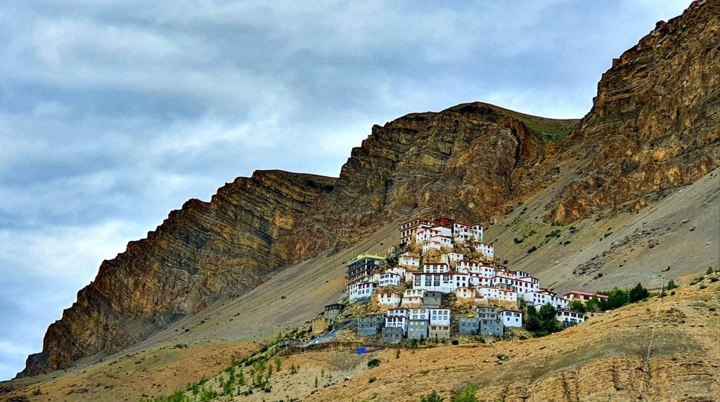
From Kibber, go on to Key village and Key Monastery. This Tibetan Buddhist monastery looks like a fortress from a distance, perched on a bare hill with the Himalaya behind it. The car can drive up to the monastery, so you do not need to hike. Spend some time inside to see the monks’ daily life and enjoy the views over the valley.
Here is my photo travel guide to the Key Monastery.
That is all for Day 4. Your driver will take you back to Kaza for a good night’s sleep.
Day 5: Langza, Komic and Hikkim
Today you visit three very different villages on a day trip from Kaza. If you got on well with your driver yesterday, ask him to take you again.

Your first stop is Langza, about 14 km from Kaza. From the village, at about 4,325 metres, you look up at the snowy Chau Chau Kang Nilda peak, which rises to about 6,300 metres. The calm here is hard to match, so find a quiet corner and sit for a while. Langza is also famous for fossils, so you can go looking for some.

From Langza, go to Komic, which at about 4,587 metres claims to be one of the highest villages in the world connected by road, and is the highest point most visitors reach in Spiti. Spend some time at Tangyud Gompa, the monastery here. When I visited, I had a delicious lunch at Spiti Organic Kitchen in Komic.

Your last stop is Hikkim, at about 4,400 metres, which claims to have the highest post office in the world. Post a letter or a postcard home from here to mark the moment.
If you think all this is just about being the “highest”, you are wrong.

These villages have some of the most breathtaking views in Spiti. Have your camera ready on the drive back down from Hikkim to Kaza.
Read my travel guide for Langza, Komic and Hikkim.
Day 6: Mud Village in the Pin Valley

On your last full day in Spiti, go to Mud (or Mudh) village in the Pin Valley. It is about 50 km from Kaza, roughly two hours each way by 4WD. Around halfway, you notice the landscape getting greener than the bare main valley. Mud is the last village in the Pin Valley that you can reach by road, and the drive there is as beautiful as the village itself. The Pin Valley is a national park, so a forest entry fee may apply here too.

In Mud, you can do several short hikes or simply walk through the village. Wherever you look, the scenery is beautiful. Many people start the multi-day Pin Parvati trek from here; if you want to do it, add at least a week to your trip.
Head back to Kaza in the evening.
Read my travel guide to Mud village in Pin valley.
Day 7: Kaza to Manali, Then the Night Bus to Delhi
This is the end of your time in Spiti, and it is a sad day. You will wonder why you have to leave so soon and when you can come back. And if you want to reach Delhi, you have around 24 hours on the road ahead of you.
To get to Manali, either take the HRTC bus from Kaza or book a seat in a shared 4WD a day ahead. In 2026, the HRTC bus left Kaza at about 5:30am and reached Manali at about 4pm, but timings change each season. If you have not booked anything, go to the taxi union office in Old Kaza, where you should find other travellers to share with.

You take the same road back, but the journey from Kaza to Manali looked even more beautiful to me. Try to get a window seat for photos. Be ready for delays: a flock of sheep might block the road, villagers might wave down your vehicle and squeeze in (possibly on your lap), or a broken-down car might hold everyone up. Keep smiling and enjoy it.

As you go on, the brown mountains start to disappear. Once you see green again, after Batal, you know you have left the cold desert of Spiti behind.

Expect traffic near the Atal Tunnel and around Solang, especially on weekends and in peak season. On a good day, it barely slows you down; on a bad day, you can be stuck for hours.
If you leave Kaza by 6am in a shared taxi, you should reach Manali by about 6 or 7pm. If you can spare the time, spend the night in Manali and take the Delhi bus the next evening, as going straight on is exhausting.
I went straight to the HPTC Volvo bus stand in Manali as soon as I got back from Kaza. There were plenty of buses waiting to leave for Delhi. I had no ticket, but I got on one that still had a seat, and I was so tired that I fell asleep straight away. The bus stopped once around midnight at a roadside restaurant, which is your chance to eat and use the toilet.
Day 8: Early Morning Arrival in Delhi
You arrive in Delhi early in the morning, which is the end of this 7-day Spiti Valley itinerary from Delhi via Manali. From Delhi, you have plenty of options. You could spend 2 days in Delhi, then head to Agra to see the Taj Mahal and on to Jaipur, the Pink City.
How to Adjust This Itinerary
I had only seven days from Delhi, and it worked for me: long enough to see the main sights without rushing too much, and short enough to fit around my work. It is a fast plan for this altitude, though, so change it to suit you.
If you have more time, stay a night in one of the villages above, such as Langza or Kibber, or go on a short hike or a longer trek. You could also do the full Spiti circuit, coming in from Manali and leaving through Kinnaur towards Shimla. Indians need no permit for this, but foreigners need a Protected Area Permit for Tabo, Dhankar and the Kinnaur belt; my Spiti Valley permit guide explains how to get one.
If you are short of time, skip Chandra Taal and drive straight from Manali to Kaza without the night at Batal. You can shorten the trip further by dropping Mud village, but keep at least one spare day for road closures or altitude problems.
Spiti is not a year-round destination by this route. In winter, heavy snow closes Kunzum La and the Manali road. The road usually opens in late May or June and stays open until October, and June to September is the safest window. Always check the weather and road conditions before you set off.
Whatever you choose, you cannot go wrong. The moment you arrive in Spiti, you will understand why. For where to stay and eat in Kaza, see my Kaza travel guide.
Spiti Valley Itinerary FAQs
How long does it take to reach Kaza from Manali?
Manali to Kaza is about 200 km via the Atal Tunnel and Kunzum La. It takes 9 to 12 hours in one go, or two days with a night at Batal as in this itinerary. From Delhi, add 12 to 14 hours to reach Manali.
Do you need a permit for Spiti Valley?
Indian citizens do not. Foreigners can travel from Manali to Kaza and around Kibber without a permit, but need a Protected Area Permit for Tabo, Dhankar, Gue and the Kinnaur belt towards Shimla. The Atal Tunnel route no longer crosses Rohtang Pass, so no Rohtang permit is needed.
Is 7 days enough for Spiti Valley from Delhi?
It is enough for the main sights around Kaza, but it is a fast plan for this altitude. Add a spare day for road closures and to adjust to the height.
What is the best time to visit Spiti via Manali?
June to September. The Manali road usually opens in late May or June and closes in October, and the side road to Chandra Taal opens later, often from mid-June.
Is altitude sickness a risk in Spiti Valley?
Yes. Kaza is at about 3,650 metres and the road from Manali crosses Kunzum La at 4,551 metres, so you climb very fast. Rest in Manali first, drink plenty of water, and go down if symptoms get worse.
How high is Spiti Valley?
Kaza is at about 3,650 metres. Langza, Hikkim and Komic are between about 4,300 and 4,600 metres, and Kunzum La, the highest pass on the Manali road, is 4,551 metres.
Is there an entry fee for Chandra Taal?
Yes. Since 2025, the forest department has charged entry fees for Chandra Taal, the Kibber area and the Pin Valley. When introduced, the fee was 150 rupees for Indians and 500 rupees for foreigners; check the current rate.
What is the distance from Delhi to Spiti Valley?
About 540 km from Delhi to Manali, then about 200 km from Manali to Kaza, so roughly 740 km in all via Manali.
Should I go to Spiti via Manali or Shimla?
The Manali route is shorter but climbs fast. The Shimla route through Kinnaur is about twice as long but gains height gradually, and foreigners need a permit for it. Many people go in one way and out the other.



Wow! 😍 this post is incredible, makes me want to travel right now. Thank you so much for sharing
Thank you, Rachael.