Brow Head, near Crookhaven in West Cork, is the true southernmost point of mainland Ireland, not Mizen Head, as almost every guide assumes. It’s a wild, unmarked headland reached by a short walk from the coast road, with sweeping Atlantic cliff views, a ruined Napoleonic signal tower, and a remarkable connection to Marconi’s earliest wireless experiments. Here’s how to find it, what the walk involves, and why this overlooked spot deserves a place on your Mizen Peninsula day.
Almost Everyone Gets This Wrong
Here’s something hardly any travel guide will tell you: Mizen Head is not the southernmost point of Ireland.
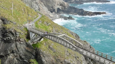
It’s the most south-westerly point, the famously dramatic one, the one with the bridge and the signal station and the visitor centre and the car park. But if you want to stand at the actual southern tip of mainland Ireland, you have to go past Crookhaven village, up a rough track and across a clifftop, to a place so overlooked that most people who visit the Mizen Peninsula have never heard its name. Brow Head.
The margin is almost comically thin. Brow Head sits about nine metres of latitude further south than Mizen Head. Nine metres. And yet there it is, the true end of Ireland, with no signpost to announce it, hardly anyone around, a ruined Napoleonic signal tower for company, and nothing between it and Antarctica but open water.
It quietly became my favourite stop on the peninsula.
What Is Brow Head?
Brow Head is a headland just west of Crookhaven village, on the southern coast of the Mizen Peninsula in West Cork. At its tip, around 51°28’N, it’s the southernmost point of mainland Ireland.
Two things make it worth the effort. The first is the clifftop views, which sweep across the Atlantic and back along the peninsula coastline. The second is history: the remains of a Marconi wireless station, one of the earliest anywhere in the world, set up here in 1901.
The headland is wild, exposed and largely untouched. No facilities, no formal viewpoints, no entry fee. Just the land, the wind, the gorse and the sea.
The Marconi Connection
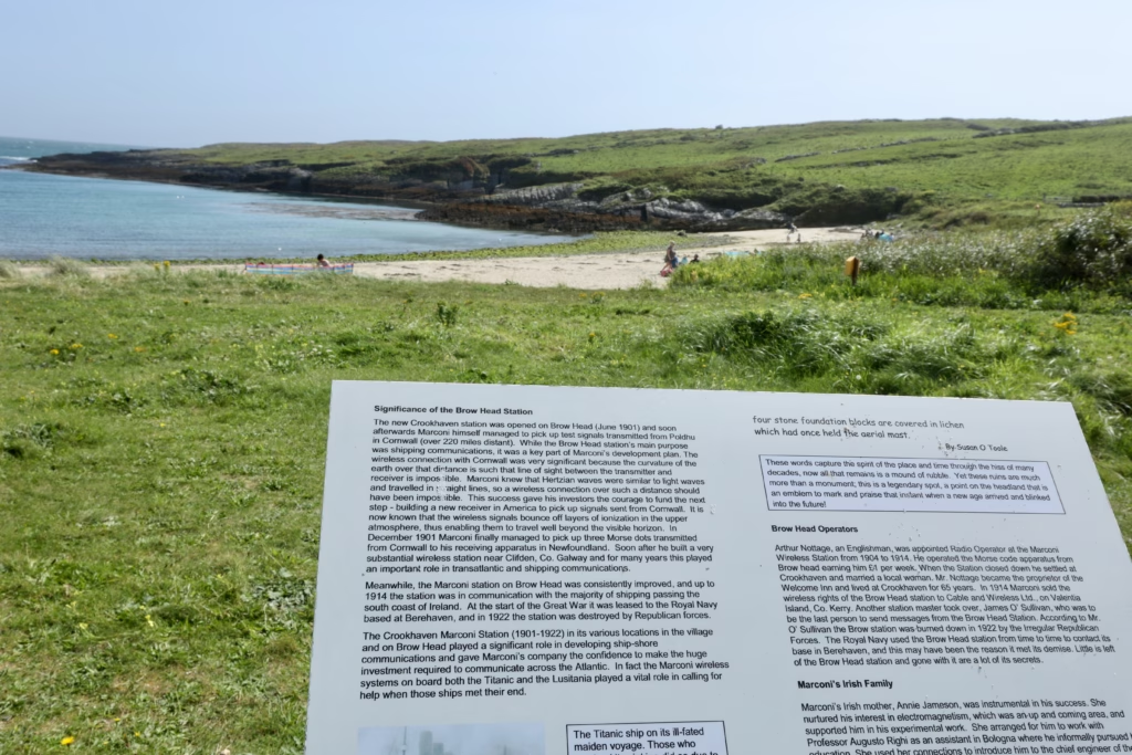
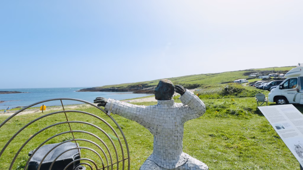
Before you head up to Brow Head, stop at the Galley Cove Beach car park below it, where an information board and a striking sculpture tell the story of what happened here.
In 1901, Guglielmo Marconi set up a wireless station at Brow Head as part of his pioneering work on transatlantic radio. The Crookhaven station was among the first in the world and became a key link in ship-to-shore communication through the early 20th century. Most strikingly, Marconi wireless systems were in use aboard both the RMS Titanic and the RMS Lusitania, and the distress calls from both ships moved through stations tied into this same network. The Brow Head station was destroyed by Republican forces in 1922, and almost nothing of the original now survives.
A few steps away stands the memorial that locals put up to mark what the headland meant, and it’s worth a moment before you start the climb.
Getting to Brow Head
You reach Brow Head from Crookhaven village or, more usually, from the Galley Cove Beach car park about 1.5km west of Crookhaven on the road that runs on toward the headland.
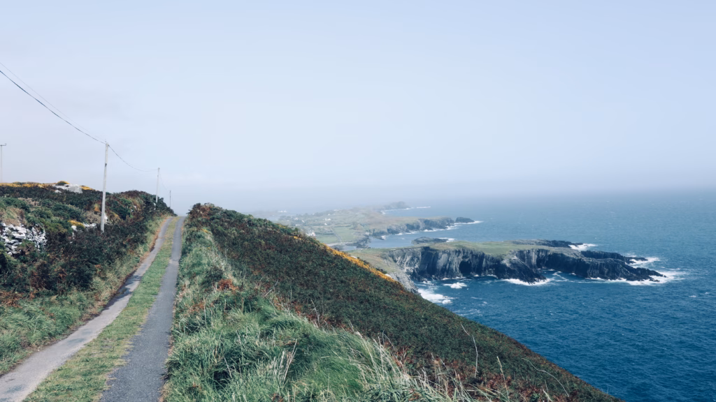
There’s no proper car park at the headland itself. Most people leave the car at Galley Cove and walk up, or find a safe pull-in on the lane closer to the top. The track to the clifftop is unmaintained and unmarked, which is part of the appeal and part of the reason so few people bother. From Mizen Head it’s about 15 to 20 minutes by car; from Cork city, roughly 2.5 hours.
If you’re coming from abroad and need wheels, Discover Cars is worth a look for Cork Airport rates, since it compares several suppliers at once and usually beats booking direct. Go for something small, too; the narrow lanes out here are far easier in a compact.
The Walk
The climb up to Brow Head from the lane is short, around 20 to 30 minutes to the clifftop, but the ground is rough and the payoff comes almost at once.
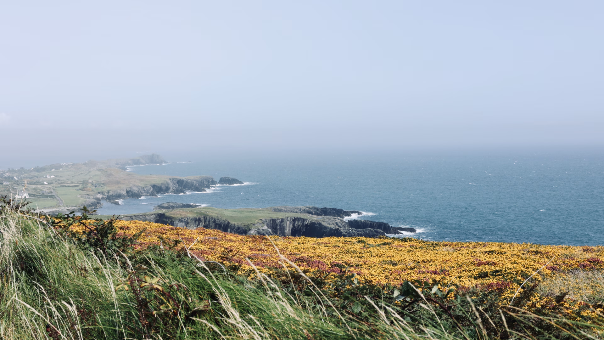
The headland is blanketed in gorse and heather that flare yellow and purple in late summer, a carpet of colour set hard against the grey-blue Atlantic below. August is the peak of it, and that gold-on-blue is one of those combinations so vivid it looks faintly unreal in photographs.

As you climb, the views unfold in stages: first across the inlet toward Crookhaven, then south and west over open ocean, then east along the peninsula coastline running off in both directions. The track itself adds to the drama, narrow and exposed, the land dropping straight to the sea on one side.
The clifftop is raw in a way that feels rarer every year. No fencing, no barriers, no platforms. The edge is simply where the land stops, and you stand as near to it as your nerve allows. Below, the Atlantic meets the rock with a force you feel as much as hear.
The Signal Tower
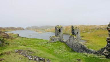
Near the tip of the headland stands the ruin of a Napoleonic-era signal tower, built in 1804 as one link in a chain of coastal watchtowers thrown up around Ireland during the threat of French invasion. It’s square and solid, slowly being taken back by lichen and weather. Nothing about it is restored, fenced or managed. It just stands there, as it has for more than two centuries.

Stand at the tower, with the Atlantic on every side and the peninsula spread out below, and the choice of site explains itself. You can see for miles. On a clear day Fastnet Rock is out there, the lighthouse 13km offshore that the emigrants called “Ireland’s Teardrop” as it slid from view, and the coast runs north toward the Kerry mountains.
The View That Makes It Worth It
From the clifftop, the Mizen Peninsula finally shows itself for the dramatic, complicated stretch of coast it really is.
Look back toward the headland and Galley Cove lies below you, the sheltered sand, the turquoise water, the farmland climbing behind it. Further east, the peninsula road threads across the hillside and the West Cork coast runs off into the distance. Turn south and west and there’s simply nothing: open ocean all the way to North America.

Swing your eye the other way, east along the coast, and the cliffs do something different again, layered and folded, the gorse running right to the edge.

Schull: The Village You Pass Through
Between Bantry Bay and Brow Head you pass through Schull, a small harbour village that deserves more than a glance through the windscreen.
Schull is West Cork distilled: painted shopfronts, a sailing harbour, good cafés, and an arts scene far bigger than the size of the place would suggest. It even has a planetarium, the only one in the Republic outside Dublin. In summer it fills up with sailors and walkers and people who’ve found it and quietly kept it to themselves.
If you’re making a day of the peninsula, pull in at Schull for coffee on the way out or a meal on the way back. You won’t regret it.
Brow Head: Practical Information
Getting there is straightforward enough: from Crookhaven village, follow the road west, then park at Galley Cove Beach or find a pull-in on the lane toward the headland. Reckon on 20 to 30 minutes up to the clifftop and about an hour for the round trip at an easy pace. It’s free, with no entry fee and no facilities of any kind. Wear trail shoes or boots, since the ground is uneven and often wet, and aim for May to September for the best weather and the strongest gorse and heather colour; early morning if you want the place to yourself. It also pairs naturally with other stops: Galley Cove Beach sits directly below and is 20 minutes away, Mizen Head is 15 to 20 minutes by car, and Three Castle Head about 25.
Is It Worth It?
More than Mizen Head, in some ways. Not because it’s more dramatic, Mizen Head’s gorge and bridge are genuinely hard to beat, but because Brow Head is completely unmanaged. No entry fee, no car park, no visitor centre, no path, no railing, no café. Just the headland, the tower, the gorse, and the quiet fact that you’re standing at the southern end of Ireland with almost nobody aware you’re there.
That mix of real geographical meaning, true wildness and a complete absence of infrastructure is getting harder to find anywhere. Brow Head still has it in full.
Go. Stand at the edge. Look south. There’s nothing between you and Antarctica.
Also on the Mizen Peninsula
- 👉 Galley Cove Beach, the sheltered cove with the Marconi story
- 👉 Mizen Head Signal Station, the bridge, the gorge, the signal station
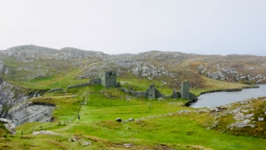
- 👉 Three Castle Head / Dunlough Castle, the medieval ruin above the lake
- 👉 The full Mizen Peninsula day trip guide from Cork
Prefer a guided trip? The West Cork to Mizen Head Full Day Tour from Cork takes in Brow Head, Galley Cove and Mizen Head with a local guide, worth it if you’d like some context with your cliffs.
Been to Brow Head yourself? Drop a comment, I’d love to hear how you found it.
Save this for your West Cork road trip planning, and share it with anyone who still thinks Mizen Head is the southernmost point of Ireland.
Every guide on A Walk in the World is written to help you have the best possible trip. I only recommend hotels, tours, and experiences I'd genuinely choose myself, and I don't accept payments or sponsorships from operators in exchange for positive coverage. Some of the booking links on this site are affiliate links, which means I may earn a small commission if you book through them, at no extra cost to you. Thanks for trusting my guides and supporting the blog!
Leave a reply